Case study prepared by Alicia Ghadban, Carleton University
Flooding Impacts on Heritage Properties in Calgary, Alberta and surrounding area
KEYWORDS Climate Change / Natural Disaster / Flooding / Disaster Response / Heritage Inventories / Risk Management / Risk Assessment
LESSONS Over the past two decades there has been growing concern for human impact on climate change and its influence has been seen globally with increasing natural disasters such as earthquakes, hurricanes, tsunamis, floods, and many others. With changes to our natural environment, the frequency and magnitude of these disasters have also shifted, requiring communities to adjust in order to mitigate these impacts. In the event of a disaster, health and safety of community members undoubtedly takes precedence while cultural heritage is frequently excluded from government disaster policies and planning. For this reason, cultural institutions and organizations are encouraged to develop their own disaster and emergency preparedness plans that outline procedures and reduce the effects of disasters. Nevertheless, what happens when these plans are not developed? With the recent event that hit southern Alberta, heritage authorities were forced to improvise and rely heavily on material publically available such as the English Heritage guide, Flooding and Historic Buildings. This occurrence identifies and supports the perception that disaster preparedness strategies and management policies are needed in order to mitigate threats and reduce the impact by sustaining built and natural environments.[i] [ii]
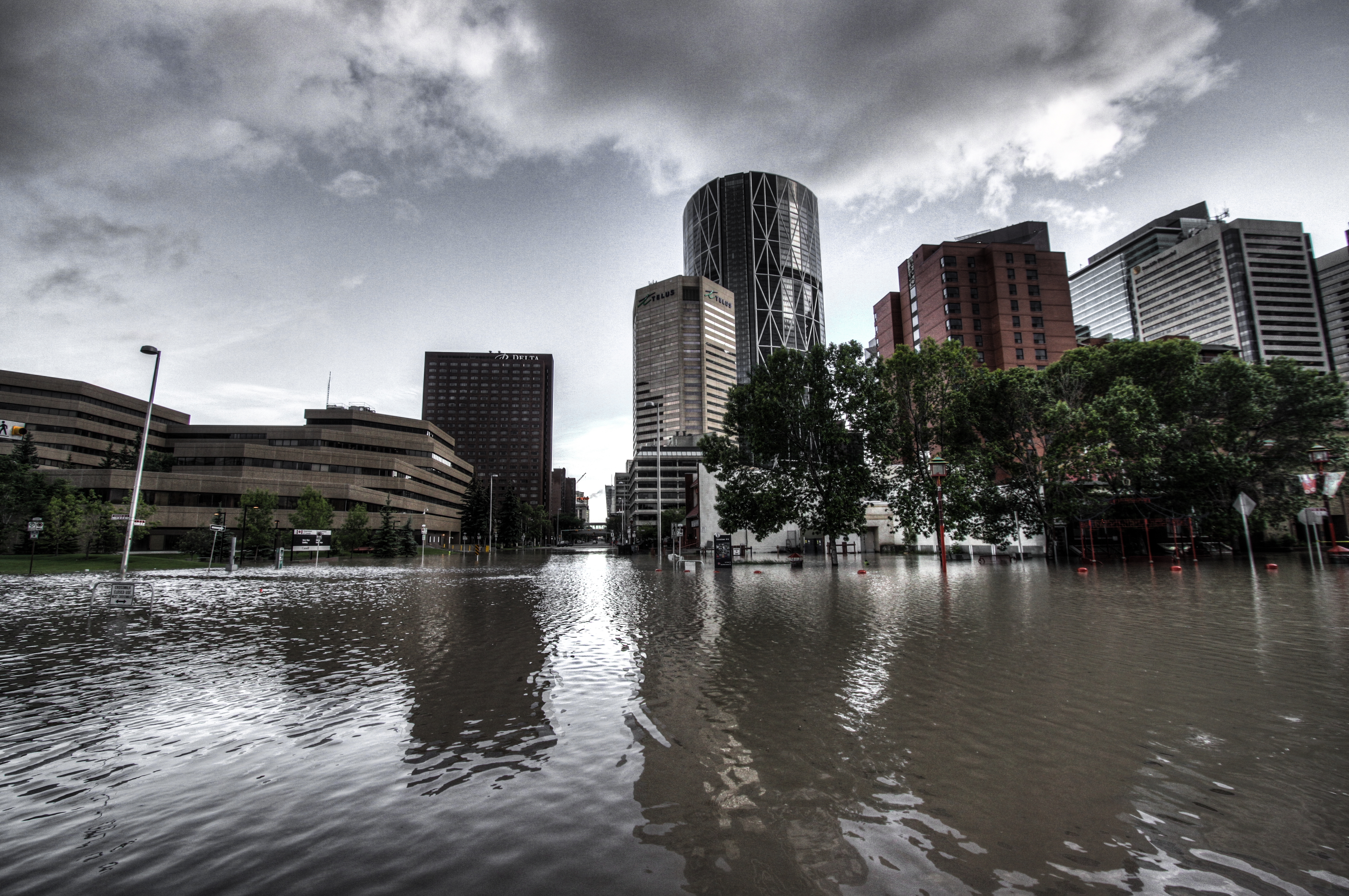
View of downtown Calgary during the 2013 flood. Credit: Quan, Ryan. (Photographer). (2013). Floods 2013 Skyline. [Photograph]. Retrieved from http://www.flickr.com/photos/ryan_quan/9147845946/in/photostream/
There were two main environmental factors that attributed to the cause of the recent flood. For one, the area experienced greater snow fall during the winter months and was followed by greater rainfall during the spring. This led to saturated grounds and fuller streams and rivers, leaving no room for additional rain. Secondly, a high-pressure system in northern Alberta blocked the passage to a low-pressure area to the south causing winds from the east to push humidity forward. This led to heavy rainfall of amounts over 200 millimetres (7.9 inches) in less than two days.[v]
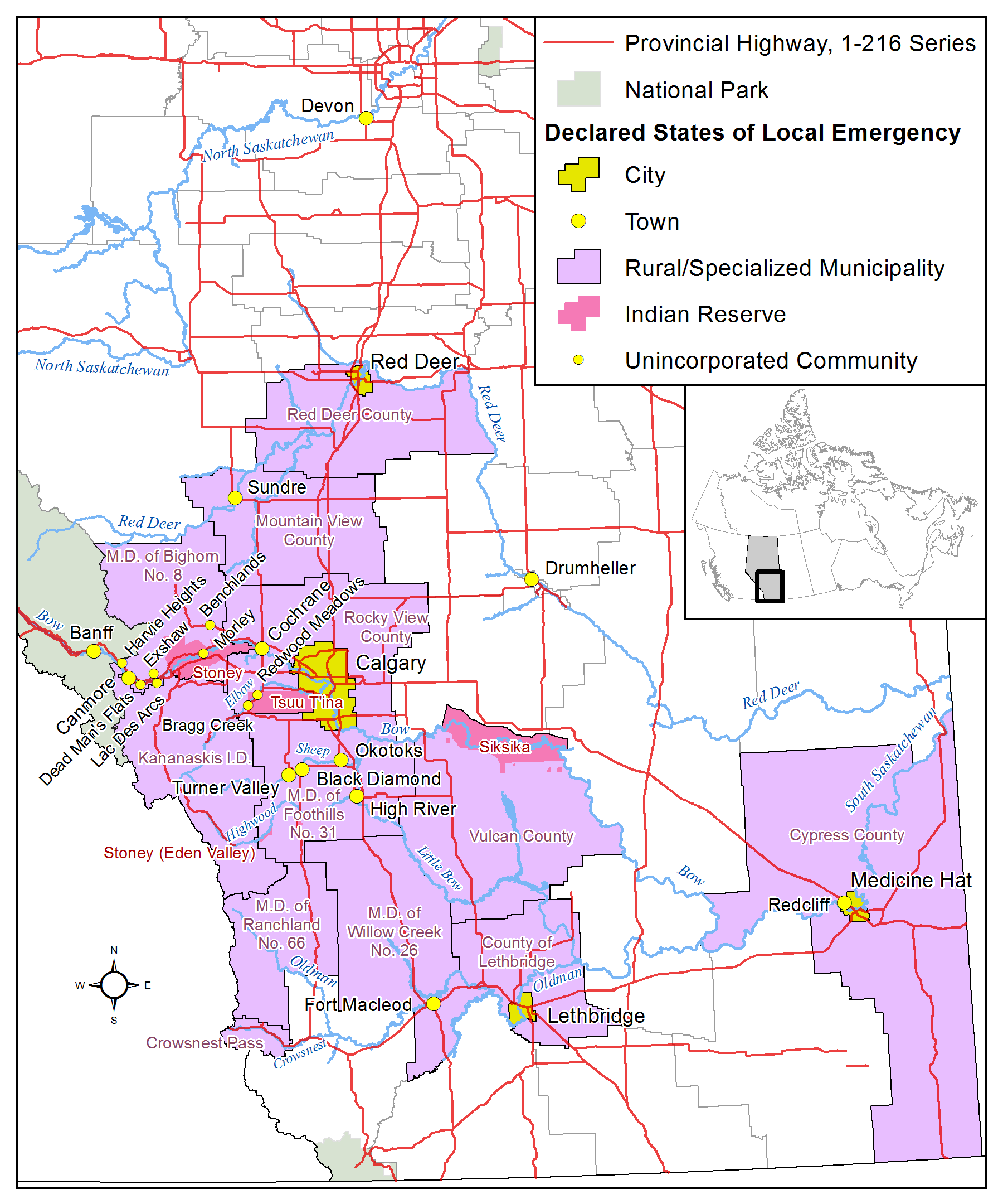
Map of Southern Alberta Illustrating Declared States of Emergency. Credit: Hwy43. (2013). Map of southern and central Alberta showing rivers that flooded and declared states of local emergency. [Map]. Retrieved from http://commons.wikimedia.org/wiki/File:2013_Alberta_floods.png
Long history of Aboriginal presence (pre-Clovis; Blackfoot, Sarcee and Stoney tribes)
1860s: European settlement with the fur trade, bison hunters from the United States, and illegal whiskey traders
1869: settlement of Canadian West commenced
1874: the North-West Mounted Police were stationed in southern Alberta to protect native people from illicit activities
1875: Fort Calgary was built at the union of the Bow and Elbow rivers to remove the whiskey traders
1883: the area was linked to the Canadian Pacific Railway (leading to future residential and business developments around the Bow River)
1884: officially incorporated as the Town of Calgary[vi]
Note: The history of all affected areas has not been noted in this study. Calgary was chosen as it is the largest affected municipality and its settlement pattern easily demonstrates the relation between early transportation via water and urban development.
TIMELINE (Of Event) On 19 June 2013, Alberta Environment issued a high streamflow advisory but within 24 hours, the advisory rapidly changed to flood watch, then to flood warning for much of southern Alberta. The following day, the Municipal Emergency Plan (MEP) was activated by Calgary, and states of emergency were declared by Calgary and Canmore. Evacuation orders were also issued for low-lying areas of Calgary and subsequently extended to 26 neighbourhoods within the metropolitan area. On June 21, roads, bridges and access to downtown were closed as the water levels of the Bow and Elbow Rivers continued to rise. In addition, the Town of Medicine Hat also declared a state of emergency. On June 22, the rivers in Calgary began to recede though the South Saskatchewan River continued to rise and evacuation orders were given for Medicine Hat. The following day, the evacuation order for Calgary residents was lifted while the North Saskatchewan River continued to rise – threatening Medicine Hat. By the end of the flood, a total of 32 states of emergency had been declared.[vii] [viii] [ix] [x]

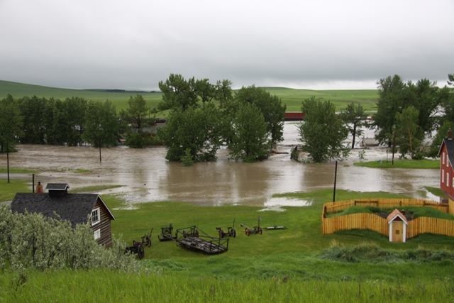
Flood outside the Museum of the Highwood. Credit: Alberta Culture: Government of Alberta. (Photographer). (2013). In the path of the flood. [Photograph]. Retrieved from https://www.flickr.com/photos/albertaculture/12172739325/in/set-72157640206026836/
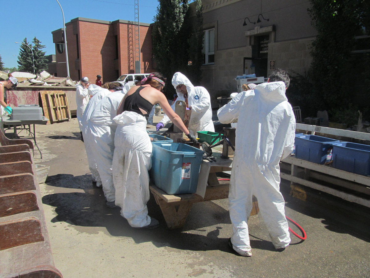
Individuals dealing with the aftermath of the flood. Credit: Alberta Culture: Government of Alberta. (Photographer). (2013). Help for the Highwood. [Photograph]. Retrieved from https://www.flickr.com/photos/albertaculture/12171699286/in/set-72157640206026836/
Note: The dates and occurrences vary on community, accessibility, funding sources, contractor availability, etc.
STAKEHOLDERS In Alberta, provincial and municipal site designations are protected under the Alberta Historical Resources Act making the Government of Alberta and the Alberta Historical Resources Foundation major stakeholders. These sites are then managed using the Standards and Guidelines for the Conservation of Historic Places in Canada. Historic properties are also subject to provincial and municipal building codes and bylaws however the Historic Resources Act takes precedence over these regulations. In addition, there are 59 National Historic Sites in Alberta including the Bar U Ranch which was greatly affected by the flood. The Ranch and 22 other sites are administered by Parks Canada – making it a major stakeholder as well.[xii]
View of flooding at Bar U Ranch National Historic Site. Credit: Friends of the Bar U’s. (Photographer). (2013). Flooding at the Bar U Ranch National Historic Site on June 20, 2013. [Photograph]. Retrieved from http://www.nantonnews.com/2013/06/20/critical-alerts-flood-watches-issued
NATURAL-CULTURAL HERITAGE According to Calgary’s Inventory of Evaluated Historic Resources, there are over 700 significant sites within the city but only a number of them possess legal protection by the Province or the City, as designated Provincial Historic Resources or Municipal Historic Resources, respectively. The online inventory identifies 6 federal, 60 provincial and 60 municipal designations that range from historic buildings to cultural landscapes and archaeological sites. However, the Canadian Register of Historic Places identifies 78 designated sites in Calgary. With that being said, some communities lack the presence of heritage inventories while others are still in the process of developing and compiling inventory systems.
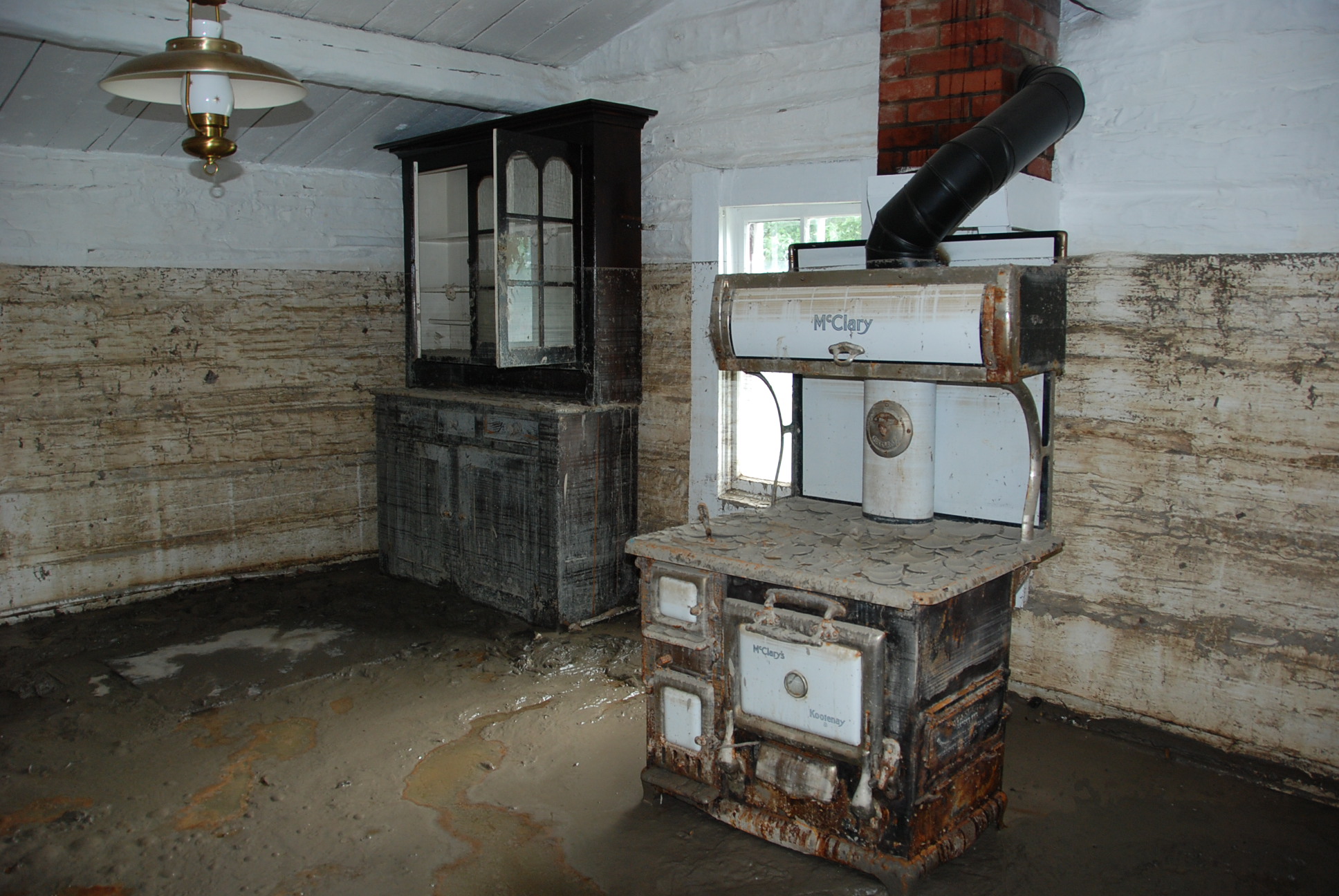
Interior of Maccoy House (post-flood). Credit: (Retroactive Blogger). (2013). Flood impacts to the Maccoy House, a Municipal Historic Resource, in High River. [Photograph]. Retrieved from https://albertashistoricplaces.wordpress.com/2014/01/27/major-funding-announced-for-flood-impacted-historic-places-2/
SUSTAINABILITY “The threats posed by global climate change present[s] us with the need and opportunity to develop an integrated approach to preserving and sustaining the built and natural environments” by combining and consolidating our efforts and resources.[xv] Though climate change is a global threat, the preservation of heritage is more local with work being done at the provincial and municipal level. In addition, a good planning and mitigation strategy requires that the efforts by flood control individuals and emergency response teams are well-integrated with those responsible for cultural heritage. The strategy must also address means to reducing risk, increasing flood resistance, enhancing early flood warnings and detections, and include proper flood-response planning. Flooding and Historic Buildings by English Heritage is an excellent guide that provides advice on preventative measures, performing inspections, and the conservation and repair of historic buildings after a flood has occurred. The document also recommends a comprehensive photographic record as being a valuable resource for capturing internal and external aspects of the building in the event that repairs are needed. This partocular technique would be extremely beneficial for heritage properties that have been hit by any form of disaster, not just flooding.[xvi] [xvii] [xviii] [xix]
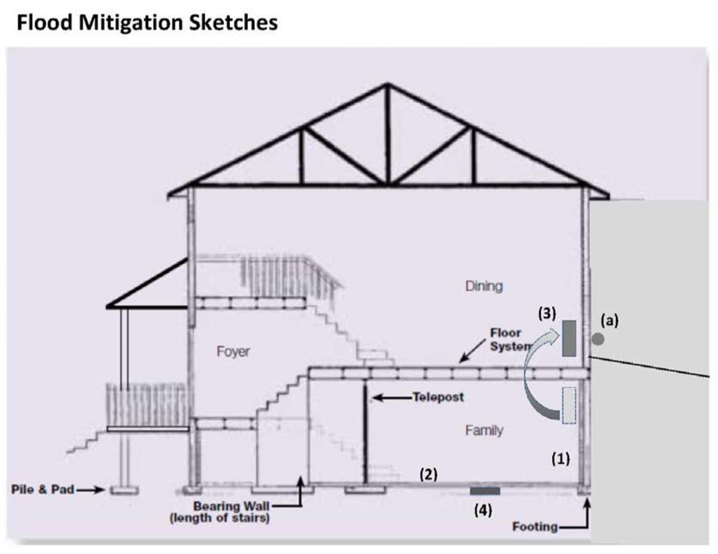
Diagram of Flood Mitigation Sketches. (1)-(2): Use cleanable moisture resistant material for easy disposal and restoration. (3): Relocate electrical panel, (a): mount a service disconnect switch. (4): Install a backflow preventive device. Credit: Alberta Municipal Affairs. (2013). Building Code Bulletin: Standata, Disaster Recovery Program Flood Mitigation Measures. [Diagram]. Retrieved http://www.municipalaffairs.alberta.ca
MEASUREMENT As previously noted, provincial and municipal site designations are protected under the Alberta Historical Resources Act. To qualify for provincial designation and protection, historic places must normally “be associated with an important aspect of Alberta’s natural or human history,” “be of outstanding provincial significance,” “be situated in their original location,” and “retain the physical site features necessary to convey their significance.”[xxii] As previously discussed, heritage advisors assigned ratings based on heritage value in order to prioritize their flood response. The details of the value system have not been identified however a combination of provincial and municipal criteria may have been implemented. Criteria for municipal designations vary from community, however only Calgary’s criteria will be outlined in this study.
Since 2008, the City of Calgary has used a system based on nine criteria of significance to evaluate heritage. These conditions include: an association with an activity significant to the municipality’s history; an association with an event significant to the municipality’s history; an association with a significant institution in the municipality’s history; an association with a significant person in the municipality’s history; embodies a distinct architectural style; incorporates elements of previous design; possesses characteristics of a period/method of construction; possesses special visual value as a landmark; and has acquired symbolic value. In addition, the system is based on six criteria of integrity including: location, design, environment, materials, workmanship, and association.[xxiii]
In terms of environmental assessments, the Government of Alberta has been conducting flood hazard studies since the 1970s, and its original Canada-Alberta Flood Damage Reduction Program (FDRP) has been replaced by the current Flood Hazard Identification Program (FHIP). The FHIP conducts flood hazard mapping using GIS technology that outlines flood hazard areas along streams and lakes using design flood levels established from flood studies. One major downfall to the program is that not all communities have had studies or mapping completed.[xxiv] [xxv]

Screenshot of Flood Hazard Map Application. Credit: Government of Alberta. (n.d.). Flood Hazard Identification Program. Retrieved from http://esrd.alberta.ca/
In moving forward, GIS systems and environmental maps should be expanded to include heritage properties so sites can easily be identified by mapping past, potential and existing flood impacts. Identifying the level of risk associated with each site (e.g. low, moderate, severe) would also assist and limit the amount of preparation time during disaster response. By digitally standardizing this information, it provides all other agencies to easily access, prepare and respond promptly.[xxvi] For this reason, complete and fully accessible documentation is extremely important during the recovery and rehabilitation stage.
SOURCES
POLICIES AND DOCUMENTS
- Alberta Municipal Affairs. (2013). Building Code Bulletin: Standata, Disaster Recovery Program Flood Mitigation Measures. Retrieved http://www.municipalaffairs.alberta.ca
- English Heritage. (2010). Flooding and Historic Buildings. Retrieved from http://www.english-heritage.org.uk/publications/flooding-and-historic-buildings/flooding-and-historic-buildings-2nd-ed.pdf
- Government of Alberta. (2014). June 2013: Southern Alberta Floods: One-Year Report. Retrieved from http://alberta.ca/
- Stovel, H. (1998). Risk Preparedness: A Management Manual for World Cultural Heritage. Rome: ICCROM. Retrieved from www.iccrom.org/ifrcdn/pdf/ICCROM_17_RiskPreparedness_en.pdf
ACADEMIC ARTICLES
- Berenfeld, M. L. (2008). “Climate Change and Cultural Heritage: Local Evidence, Global Reponses.” George Wright Forum, 25.2.
- Boersma, F. (2008). Where’s the Fire?: Teamwork for Integrated Emergency Management. The GCI Newsletter, 23.1. Retrieved from http://www.getty.edu/
- Foran, M. L. (2010). Calgary. In The Canadian Encyclopedia. Retrieved from http://www.thecanadianencyclopedia.ca/
- Kolafa, P. (2013). 2013 Flood Timeline. The Drumheller Mail. Retrieved from http://search.proquest.com/docview/1521667159?accountid=9894
- Levin, J. (2008). Putting Heritage on the Map: A Discussion about Disaster Management and Cultural Heritage. The GCI Newsletter, 23.1. Retrieved from http://www.getty.edu/
- McCarthy, D. (2013). Facing Disaster: The Importance of Heritage Inventories in Preparation and Response. The GCI Newsletter, 28.2. Retrieved from http://www.getty.edu/
WEBSITES
- CBC News. (2013). Harry Sanders: A Quick History of Calgary Floods. Retrieved from http://www.cbc.ca/
- City of Calgary. (n.d.). Calgary Heritage Authority. Retrieved from http://www.calgary.ca/
- City of Calgary. (n.d.). Heritage Evaluation Procedure and Criteria. Retrieved from http://www.calgary.ca/
- City of Calgary. (n.d.). YYC Flood Timeline 2013. Retrieved from http://www.calgary.ca/
- Environment Canada. (n.d.) Alberta Floods. Retrieved from http://www.ec.gc.ca/
- Environment Canada. (n.d.). Canada’s Top Ten Weather Stories for 2013. Retrieved from http://ec.gc.ca/
- Government of Alberta. (n.d.). Archived Advisories & Warnings – June 2013. Retrieved from http://www.environment.alberta.ca/
- Government of Alberta. (n.d.). Flood Hazard Identification Program. Retrieved from http://esrd.alberta.ca/
- Government of Alberta. (2014). Alberta Historic Places Designation Program. Retrieved from http://culture.alberta.ca/
- Government of Alberta. (2014). List of Spring and Summer 2014 Grant Recipients. Retrieved from http://culture.alberta.ca/
- Parks Canada. (n.d.). National Historic Sites in Alberta. Retrieved from http://www.pc.gc.ca/
- Statistics Canada. (n.d.). Focus on Geography Series, 2011 Census: Census Metropolitan Area of Calgary, Alberta. Retrieved from http://www12.statcan.gc.ca
- The Canadian Press. (2013). Flooding Timeline: a Devastating, Drenching June for Alberta. Retrieved from http://globalnews.ca/
[i] Boersma, F. (2008). Where’s the Fire?: Teamwork for Integrated Emergency Management. The GCI Newsletter, 23.1. Retrieved from http://www.getty.edu/
[ii] Berenfeld, M. L. (2008). “Climate Change and Cultural Heritage: Local Evidence, Global Reponses.” George Wright Forum, 25.2.
[iii] Statistics Canada. (n.d.). Focus on Geography Series, 2011 Census: Census Metropolitan Area of Calgary, Alberta. Retrieved from http://www12.statcan.gc.ca
[iv] CBC News. (2013). Harry Sanders: A Quick History of Calgary Floods. Retrieved from http://www.cbc.ca/
[v] Environment Canada. (n.d.). Canada’s Top Ten Weather Stories for 2013. Retrieved from http://ec.gc.ca/
[vi] Foran, M. L. (2010). Calgary. In The Canadian Encyclopedia. Retrieved from http://www.thecanadianencyclopedia.ca/
[vii] The Canadian Press. (2013). Flooding Timeline: a Devastating, Drenching June for Alberta. Retrieved from http://globalnews.ca/
[viii] Government of Alberta. (n.d.). Archived Advisories & Warnings – June 2013. Retrieved from http://www.environment.alberta.ca/
[ix] Kolafa, P. (2013). 2013 Flood Timeline. The Drumheller Mail. Retrieved from http://search.proquest.com/docview/1521667159?accountid=9894
[x] City of Calgary. (n.d.). YYC Flood Timeline 2013. Retrieved from http://www.calgary.ca/
[xi] Government of Alberta. (2014). List of Spring and Summer 2014 Grant Recipients. Retrieved from http://culture.alberta.ca/
[xii] Parks Canada. (n.d.). National Historic Sites in Alberta. Retrieved from http://www.pc.gc.ca/
[xiii] The City of Calgary. (n.d.). Calgary Heritage Authority. Retrieved from http://www.calgary.ca/
[xiv] McCarthy, D. (2013). Facing Disaster: The Importance of Heritage Inventories in Preparation and Response. The GCI Newsletter, 28.2. Retrieved from http://www.getty.edu/
[xv] Berenfeld, M. L. (2008). “Climate Change and Cultural Heritage: Local Evidence, Global Reponses.” George Wright Forum, 25.2. 78.
[xvi] English Heritage. (2010). Flooding and Historic Buildings. Retrieved from http://www.english-heritage.org.uk/publications/flooding-and-historic-buildings/flooding-and-historic-buildings-2nd-ed.pdf
[xvii] Levin, J. (2008). Putting Heritage on the Map: A Discussion about Disaster Management and Cultural Heritage. The GCI Newsletter, 23.1. Retrieved from http://www.getty.edu/
[xviii] Stovel, H. (1998). Risk Preparedness: A Management Manual for World Cultural Heritage. Rome: ICCROM. Retrieved from www.iccrom.org/ifrcdn/pdf/ICCROM_17_RiskPreparedness_en.pdf
[xix] English Heritage. (2010). Flooding and Historic Buildings. Retrieved from http://www.english-heritage.org.uk/publications/flooding-and-historic-buildings/flooding-and-historic-buildings-2nd-ed.pdf
[xx] Alberta Municipal Affairs. (2013). Building Code Bulletin: Standata, Disaster Recovery Program Flood Mitigation Measures. Retrieved http://www.municipalaffairs.alberta.ca
[xxi] Government of Alberta. (2014). June 2013: Southern Alberta Floods: One-Year Report. Retrieved from http://alberta.ca/
[xxii] Government of Alberta. (2014). Alberta Historic Places Designation Program. Retrieved from http://culture.alberta.ca/
[xxiii] The City of Calgary. (n.d.). Heritage Evaluation Procedure and Criteria. Retrieved from http://www.calgary.ca/
[xxiv] Government of Alberta. (n.d.). Flood Hazard Identification Program. Retrieved from http://esrd.alberta.ca/
[xxv] Environment Canada. (n.d.) Alberta Floods. Retrieved from http://www.ec.gc.ca/
[xxvi] McCarthy, D. (2013). Facing Disaster: The Importance of Heritage Inventories in Preparation and Response. The GCI Newsletter, 28.2. Retrieved from http://www.getty.edu/